


AutoScene Draw for Railroad & Rail Transit
Scene Diagramming Built for Railroad Safety Teams, Rail Police, and Risk Managers
Whether you're documenting a derailment that shut down a mainline, mapping a grade crossing collision for the FRA, or coordinating a hazmat response across a sprawling rail yard, AutoScene Draw (ASD) helps you create accurate, to-scale diagrams in minutes.
Every Minute Your Track Is Down Costs You Thousands
The clock starts ticking when a derailment shuts down a line. Your team scrambles to coordinate emergency response, document the scene, notify regulators, brief insurers, and plan the cleanup. They're also trying to get accurate information as fast as possible.
And the documentation tools most rail teams are working with weren't built for this.
Most incident documentation tools weren't built for the unique demands of railroad operations. Meanwhile, you have FRA reporting deadlines, insurers demanding documentation, and legal teams that need defensible exhibits. You deserve a tool that keeps up with the speed and complexity of your diagramming needs.
What ASD Does: Accurate Rail Scene Diagrams in Minutes
AutoScene Draw (ASD) is a fast, intuitive diagramming platform purpose-built for public safety and infrastructure professionals, including railroad police, safety officers, track supervisors, risk managers, and rail transit investigators.
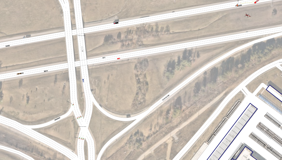
Just enter a location, and ASD auto-generates accurate, to-scale roads, track corridors, crossings, structures, and terrain using geolocation data.
When your track supervisor arrives at a derailment site, they can pull out a tablet and start building an accurate diagram immediately. ASD's intuitive interface means minimal training time. Draw track layouts, position derailed cars, mark hazmat concerns, and document grade crossings with just a few clicks.
Built for Every Incident and Operation on the Railroad
ASD isn't a one-trick tool. Here's how railroad safety teams, rail police, and risk managers are putting it to work across their operations:
Train Derailment Documentation
Map the full scope of a derailment (car positions, track damage, point of derailment, debris fields, and hazmat concerns) on a to-scale, geographically accurate diagram. Give your FRA reports, insurers, and legal team exactly what they need.
Highway-Rail Grade Crossing Collisions
Document vehicle-train collisions at grade crossings with precise positioning of vehicles, rail equipment, crossing signals, gates, and signage. Build diagrams that satisfy FRA Form 6180.57 reporting.
Hazmat Spill & Release Mapping
When a tank car breach or chemical release happens, you need to map the spill zone, evacuation perimeters, staging areas, and crew positions fast. ASD helps you create a clear visual for response coordination and National Response Center reporting.
Rail Yard Incident Documentation
Diagram coupling accidents, worker injuries, equipment strikes, and other rail yard incidents with accurate layouts of track, structures, and equipment positions, critical for OSHA and FRA compliance.
Trespasser & Pedestrian Casualty Scenes
FRA requires the reporting of longitude and latitude for trespasser casualties and detailed incident documentation. ASD lets you quickly produce a scaled diagram tied to exact GPS coordinates, simplifying your compliance.
Vehicle-Train Collision Reconstruction
Support NTSB and internal investigation teams with detailed, to-scale collision reconstructions that clearly show vehicle and train positions, sight lines, signal timing, and approach geometry.
Emergency Response & Evacuation Planning
Pre-plan emergency response for high-risk corridors, tunnels, bridges, and urban rail segments. Map staging areas, access points, helicopter LZs, and evacuation routes before an incident ever happens.
Right-of-Way & Infrastructure Planning
Use ASD to diagram construction zones, track maintenance staging, bridge work areas, and signal installation layouts. This gives your field crews and contractors a clear, to-scale visual of the work site.
Why Railroad Safety Teams Are Choosing AutoScene Draw
Diagram Any Rail Scene in Minutes
Enter a geolocation and ASD auto-generates roads, crossings, structures, and terrain instantly. What used to take hours of CAD work now takes minutes.
Built for the Field and Easy to Use
When your track supervisor arrives at a derailment site, they can pull out a tablet and start building an accurate diagram immediately. No desktop-only software. No waiting until you're back at the office.
Precision That Satisfies Regulators, Insurers, and Courts
Whether you're presenting to the FRA, your legal team, or an insurer, your diagrams need to be defensible. ASD allows you to create scale-accurate drawings with precise measurements, angles, and positions.
Drag-and-Drop Symbol Library
Add rail cars, locomotives, vehicles, hazmat markers, crossing signals, personnel, barriers, evidence markers, and more from a ready-made library. No design skills required.
3D Scan Integration with Dot3D
Pair ASD with Dot3D Pro to convert 3D video scans of derailment sites, grade crossings, and rail corridors into detailed, layered 2D diagrams overlaid on satellite imagery.
Integrates with Your Existing Systems
ASD is built to work with a multitude of reporting systems, so your finished diagrams plug directly into your existing workflow
Satellite Imagery Overlay
Auto-align your diagrams to real-world satellite imagery for instant geographic context. Critical for corridor-wide incidents, grade crossing documentation, and right-of-way disputes.
One Platform for Your Entire Operation
Stop paying for multiple tools. ASD handles everything from a mainline derailment to a rail yard injury report to a courtroom exhibit, all in one place.
How it Works: From Incident to Diagram in Three Steps
Step 1: Enter Your Location
Type in an address, GPS coordinates, or a mile marker location. ASD pulls geolocation data and builds your base map (roads, crossings, structures) automatically.
Step 2: Add Your Details
Drag and drop symbols for rail cars, locomotives, vehicles, hazmat zones, personnel, evidence markers, and more. Add measurements, labels, notes, and photos directly to the diagram.
Step 3: Submit and Move On
Export your finished diagram for FRA reporting, insurance documentation, legal proceedings, or internal records. Done. Get your line back in service.
Trusted by Public Safety and Infrastructure Teams Across the Country
AutoScene Draw is built by SmartSafety Software, the team behind Easy Street Draw and ScenePD. Thousands of law enforcement and public safety agencies have trusted our tools for over two decades.
ASD is already in use by police departments, sheriff's offices, state agencies, and logistics operations nationwide, and railroad safety teams are discovering the same speed, accuracy, and simplicity that have made SmartSafety a name in public safety diagramming.