


AutoScene Draw for School Districts & Campus Safety
Scene Diagramming Built for School Safety Teams, SROs, and District Administrators
Whether you're documenting a school zone crash, diagramming a campus incident after a lockdown, mapping an evacuation plan for an upcoming drill, or filing a report on a playground injury, AutoScene Draw (ASD) helps you create accurate, to-scale diagrams in minutes. Give your safety team, your SROs, and your first responder partners the clear, professional documentation they need.
You're Responsible for Every Student, Every Building, Every Scenario
When something happens on campus (a bus accident, a student injury, a security incident, a near-miss in the parking lot), you need clear, defensible documentation. But for most school districts, the diagramming options boil down to two choices: a hand-drawn sketch that won't hold up if a parent's attorney gets involved, or expensive, overly complex software that nobody on your team has time to learn.
Multiple US states are now passing legislation for K-12 schools to update and digitize their campus maps and share them with local first responders. Parents, school boards, and legal teams expect more thorough documentation than ever. And your safety coordinators, SROs, and facilities managers are already stretched thin. The last thing they need is another tool that creates more work.
You need something fast, accurate, and simple enough that any member of your team can use it.
What ASD Does: Professional, To-Scale Campus and Incident Diagrams
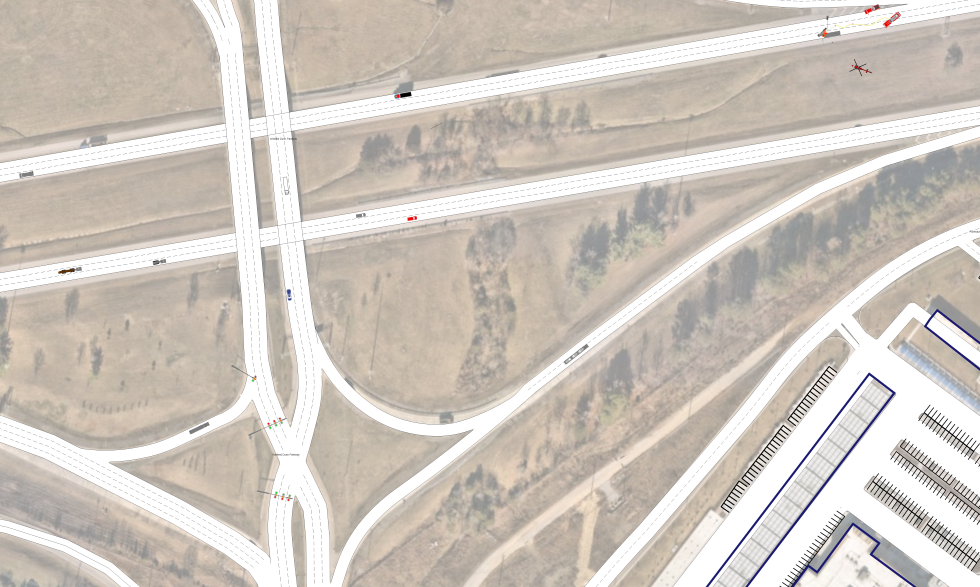
AutoScene Draw (ASD) is a fast, intuitive diagramming platform for professionals who document scenes, including school resource officers, school safety coordinators, district risk managers, facilities directors, and transportation supervisors. Just enter a school address, intersection, or GPS location, and ASD auto-generates accurate, to-scale roads, buildings, parking lots, and surrounding areas using geolocation data.
You get a professional, defensible diagram that satisfies legal requirements, insurance carriers, board presentations, and first responder coordination. Plus, your team can build it on a laptop or tablet right at the scene.
Built for Every Scenario a School District Faces
ASD isn't a one-trick tool. Here's how school safety teams and district administrators are putting it to work across their operations:
School Bus Accident Documentation
Diagram bus crashes, bus-vehicle collisions, bus stop incidents, and loading zone accidents with geolocation-based accuracy. Automatically generate the road layout, then add the bus, vehicles, students, stop signs, crosswalks, and measurements. Get the report done before the phone calls start.
Campus Incident Post-Documentation
After a lockdown, security event, fight, or medical emergency on campus, create a clear, to-scale diagram of exactly what happened and where. Document entry points, movement paths, response positions, and evidence locations.
School Zone Traffic Crash Diagramming
When a crash happens in front of your school (in the drop-off lane, on the crosswalk, or in the parking lot), ASD lets your SRO or safety coordinator create a professional diagram quickly. Document vehicle positions, pedestrian paths, signage, and traffic control devices on an accurate base map.
Playground & Athletic Injury Documentation
Document the scene of a student injury on the playground, athletic field, gym, or school grounds. Map equipment positions, surface conditions, distances, and contributing factors.
Evacuation & Reunification Planning
All school safety plans should establish a framework that is responsive to both everyday and extreme emergencies. Use ASD to create detailed, to-scale evacuation route diagrams, reunification site layouts, staging areas, and assembly points. Share them with your local fire, EMS, and law enforcement partners.
Lockdown & Active Threat Pre-Planning
Build detailed campus diagrams that show entry/exit points, hallway layouts, perimeter access, and response staging positions. Give your SROs and local law enforcement a clear, professional visual they can use for pre-planning, drill coordination, and tabletop exercises.
Construction Zone & Campus Safety
When your district is renovating a building, adding a portable, or modifying traffic flow, diagram the construction zones, pedestrian detours, temporary fencing, and equipment staging. Document safe routes for students and staff during campus changes.
Parking Lot & Drop-Off Zone Layout
Diagram your school's parking lot, bus loop, parent drop-off lane, and crosswalk configuration for safety audits, traffic flow improvements, or incident documentation. Create a clear visual to share with parents, staff, and local traffic authorities.
Why School Districts Are Choosing AutoScene Draw
Diagram Any Campus Scene in Minutes
Enter a school address and ASD auto-generates roads, buildings, parking lots, and surrounding areas instantly.
Geolocation Accuracy That Holds Up Under Scrutiny
Every ASD diagram is built on GIS-sourced map data. When a parent's attorney, insurance adjuster, or school board member asks how the diagram was produced, you have a clear, defensible answer.
Built for the Field, Not the IT Department
ASD runs on laptops and tablets. Your SRO can build a diagram right at the scene of a bus accident. Your safety coordinator can diagram a campus incident from the front office. No special hardware, no IT tickets.
Drag-and-Drop Symbol Library
Add vehicles, buses, pedestrians, barriers, evidence markers, traffic signs, cones, structures, and more from a ready-made library. If you can drag and drop, you can use ASD.
3D Scan Integration with Dot3D
Pair ASD with Dot3D Pro to turn 3D video scans of campus buildings, intersections, and facilities into layered 2D diagrams overlaid on satellite imagery for detailed safety audits or post-incident analysis.
Satellite Imagery Overlay
Automatically align your diagrams to real-world satellite imagery for instant context. See how your evacuation plan maps to the actual campus grounds. Show your fire department exactly where the staging area is.
Export-Ready for Any Stakeholder
Export finished diagrams for attachment to incident reports, insurance claims, school board presentations, law enforcement case files, or legal proceedings. Multiple formats, no extra steps.
One Platform for Everything
Stop juggling hand sketches, PowerPoint slides, and Google Earth screenshots. ASD handles everything from a bus crash report to a lockdown debrief to a full-campus evacuation plan
How it Works: From Incident to Diagram in Three Steps
Step 1: Enter Your Location
Type in your school's address, an intersection, or GPS coordinates. ASD pulls geolocation data and builds your base map (roads, buildings, parking areas, sidewalks) automatically.
Step 2: Add Your Details
Drag and drop buses, vehicles, pedestrians, barriers, cones, evidence markers, measurements, labels, and photos directly onto the diagram. Adjust anything to match exactly what you observed or what you're planning.
Step 3: Share and File
Export your finished diagram for your incident report, insurance claim, board presentation, law enforcement partner, or internal records.
Trusted by Thousands of Public Safety Professionals Nationwide
AutoScene Draw is built by SmartSafety Software, the company behind Easy Street Draw and ScenePD. Our products have been trusted by law enforcement agencies, SROs, and public safety professionals for over two decades. SmartSafety products are used in 77 countries and by more than 60% of U.S. law enforcement.
If your SROs have used Easy Street Draw or ScenePD in their law enforcement work, they already know SmartSafety. ASD takes everything they trust about those tools and brings it into a faster, more powerful, next-generation platform: one that serves the entire school district, not just the officer.